Found This In the Ground? Don’t Step On It Until You Read This

August 2, 2025
source: Reddit
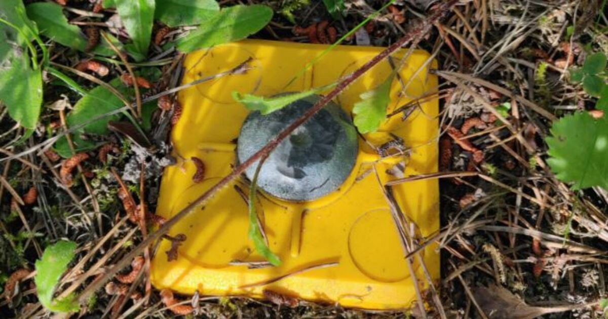
You’re wandering around your yard or along a wooded path and you notice a small, solid disc that is flush with the ground. Maybe it’s metal, often likely surrounded by plastic, possibly in bright yellow or orange. It might appear to be part of a toy, or something left behind during construction. However, it is not random.
What you see is a land survey marker. It has an important purpose, to define property lines, infrastructure, and legal land boundaries.
What is a Land Survey Marker?
A land survey marker (also called a survey monument or benchmark), is a physical reference point. It is established by a licensed land surveyor. This marks specific geographical coordinates on the surface of the Earth. Land survey markers are an integral part of defining where one property ends and another begins. They also define where new roads, utility infrastructure, or buildings will be placed.
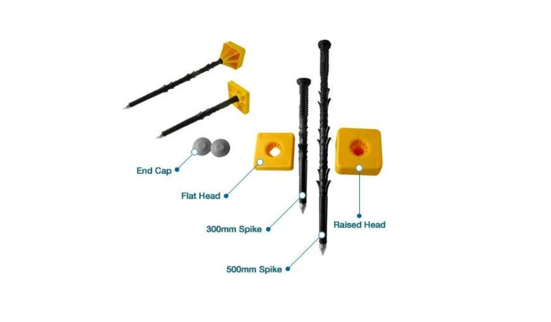
Land survey markers are durable, utilitarian items made of steel or brass. They are embedded in the ground with a cap, disk, or rod. Usually, they are surrounded by a plastic housing that is brightly colored. This raises visibility and protects them from weather environments and accidental damage.
Why Are Land Survey Markers Needed?
Land survey markers are much more than bits-and-pieces left over from construction. They have many purposes, including:
- Marking property boundaries.
- Denoting elevation benchmarks.
- Supporting legal land descriptions in deeds and titles.
- Aiding building and city planning projects.
- Helping utility companies find what is underground.
When surveyors survey a piece of land, they sometimes place markers at identifiable points. These are usually corners, or along lines that make up the boundaries of a plot. These points soon become legal references that stay on land for years and decades.
Can I move or remove one?
No. In most regions, tampering with a land survey marker is illegal. Land survey markers receive this protection because these markers are part of an official legal record of the land. Removing and/or changing a land survey marker, accidentally or not, will only cause headaches, especially if you stray into a warranted boundary dispute.
If you have a marker located off your property, and you think it is out of alignment, your best option is to find your local land surveying office. Contact a licensed land surveyor and inquire before removing it.
Who places land survey markers?
Licensed land surveyors are the only ones legally allowed to stake official land survey markers. They use specialized survey tools, total station tripods, GNSS receivers, and maps to determine the exact location. When a land surveyor stakes a marker, the marker’s location will become a matter of official land record. In some cases, it will be directly tied to national or regional geodetic systems and standards.
Surveyors complete documentation of markers carefully and maintain records of existing locations for the reference of stakeholders in the future.
You may find various types of markers. For example, in the woods, on sidewalks, embedded in concrete curbs, or sitting in your backyard. Many markers have identifiers that read as numbers and letters or symbol stamps with legal mandates.
Why do we sometimes not see them?
In many cases, land survey markers are installed flush with the ground. This is with the goal of not being tripped over or damaged. Over time, the markers can become covered with soil, grass, pine needles, leaf litter debris, and any number of accumulations. In wooded areas or rural land, it is easy for markers to be nearly invisible if you do not know where the surveyor has installed it.
Surveyors will usually take extensive notes and GPS records of where they install and mark all of them. In many instances should surveyors return they may use metal detectors or the exact coordinates they recorded earlier.
The Quiet Backbone to Land Ownership…..
A land survey marker, small pot metal disc does, does hold weight legally. For all legal matters if you ever do have an issue with matters of a similar rage, that small disc could mean the difference. The difference of the threat of you being relocated in the nature of a new fence line, locating your driveway, or keeping your neighbor to their property. It also helps with getting a building permit or construction realization or any friction you have with your neighbor.
So, if you ever notice any type of disc or marker when walking, especially something similar to the yellow covered marker in the picture above, when you encounter it remember the weightiness of what lies there, both legally and politically. Be cognizant if it is not your business when you are not engaged in business.
Did you know?
Surveying goes back centuries. Romans, Egyptians, and the earliest ‘learned and educated’ people made off some primitive surveying markers. These were used to define their farm fields and create cities and civilizations. While modern markers look somewhat different, with plastic casings and laser-leveled, the intent and legacy remain fundamentally the same. Marks, measure, and maps of certainty, need, and response for the world.
To bring it to a close:
If one day you find, identify a land survey marker, or any of its distinct relatives, treat them with as much care and respect. Because it’s not just a piece of plastic, metal of piece of borehole in the dirt, it is a piece of living, viable history. It is part of our shared existence, shared communities, or way we delineate and designate what sits under our feet.