The Secret Meaning Behind This Old NYC Survey Marker

July 11, 2026
source: Reddit
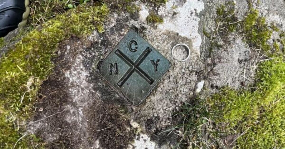
It appears to be some type of an old metal plate embedded in a rock; moss has grown around it and grass has grown near by as well as many years of weathered exposure to nature. Yet, despite all of these things, the raised letters (and) cross are still easily readable.
This is an NYC aqueduct survey Marker. The survey Marker identifies the center line of one of the water routes that connects to NYC’s massive distribution system. Although most people will simply pass right by this, the small Marker points out the foundation that led to the development of the entire city.
What is an NYC aqueduct survey Marker?
Survey markers provide permanent reference points for engineers and land surveyors. These markers can represent specific positions, elevation, boundary lines, etc., or the center lines of major structural elements.
As noted above, there are “ny” and “c” surrounding a cross. As such, the intersection represents the exact survey point. Engineers were able to use references like this during construction, inspection, and subsequent maintenance activities.
A water system hidden underground
Many people do not realize how extensive new york city’s water system actually is. Many sections of this system include aqueducts, tunnels and reservoirs which extend throughout much of New York State, but at times a significant portion of this is located under dense forestation areas, roadways, agricultural fields and solid rock. That is why the significance of this particular Marker lies in its ability to bring an otherwise invisible infrastructure to the surface and serve as a single clue to those who notice it.
Why was the centerline important to the project?
The centerline provided survey teams a primary reference point for establishing measurements along the length of the aqueduct. In addition to referencing directional data, they also referenced positional data and distance measurements over extended distances using points similar to the one shown in the photo.
An error of even a few feet could produce serious problems for workers in a tunnel or waterway. While the Marker itself is very simple in design and layout, it represents carefully developed plans. Someone had previously identified this site as having a high degree of precision in measurement. The individual(s) who placed the Marker into this rock site chose this location because it was accessible at that time and someone had subsequently installed it to allow future crews to locate this point again for further reference purposes.
Part of new york’s water history
The aqueduct aspect of new york’s water history began approximately two centuries ago. The Old Croton Aqueduct project was completed in 1842. The aqueduct brought clean water from Westchester County into lower Manhattan where it played a critical role in supporting the rapidly expanding population of the city.
Subsequent projects included larger reservoirs, tunnels and additional aqueducts. The plate in question is part of this lengthy history of public works projects involving surveys, engineering and other related aspects.
A relic from a mechanical era
Today we can determine our current location via a cell phone within seconds. However, earlier surveyors utilized primarily field notes, transits, levels, maps and permanent plates embedded in stone to accomplish their tasks.
In doing so, this NYC aqueduct survey Marker retains a certain charm. Nature has gradually encroached upon it over time. The cross still indicates the same reference point. It seems as though there is a quiet message emanating from the engineer(s) who installed it decades prior to now.
Leave it where it is
Markers such as this are not scrap metal nor decorations. Depending upon their historical significance and/or potential use in current day surveys/maintenance operations, relocating this Marker could potentially render inaccurate the point it currently represents.
Simply put: take a picture of it, record your location, and leave it alone. This small Marker occupies less than four inches of rock, however it serves as a pointer to a complex underground network of pipes/tunnels/structure that supports millions of people daily.