It Looks Abandoned, But This Creekside “Silo” Has An Important Job

June 10, 2026
source: Reddit
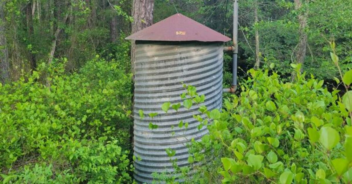
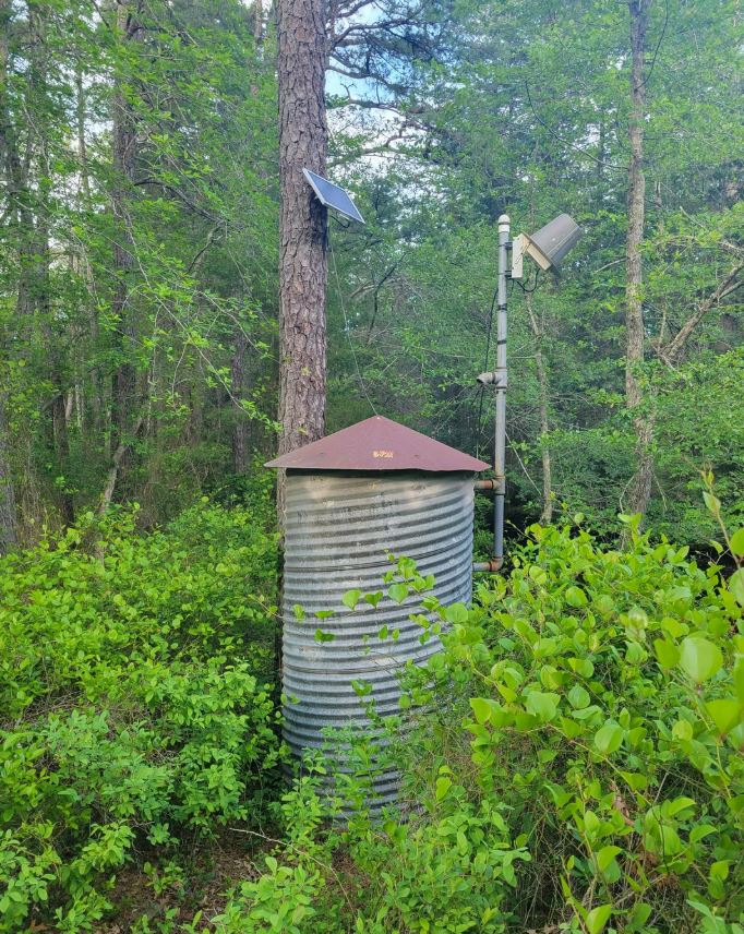
The first view of a creek flood gauge standing alone in the forest will make one think of a relic from another time. There’s a small, corrugated metal tube buried deep within the bush; a solar panel faces the direction of the light; a pole supports a peculiar-looking box pointed directly at the sky. Overall, the entire setup seems to blend in with its surroundings. It seems that only the occasional curious hiker, deer, and birds are supposed to find it.
However, despite looking as if it is hiding, this station probably plays an essential role. It monitors the water.
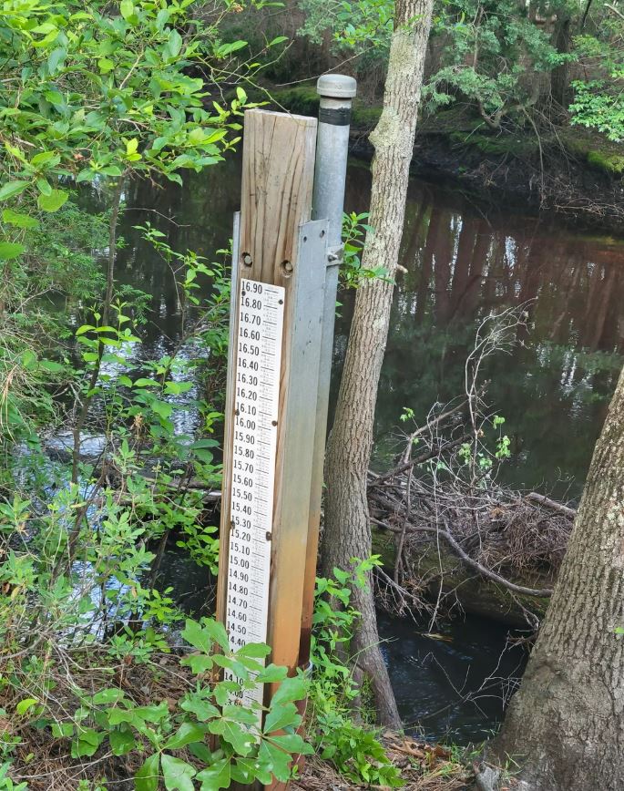
Directly behind it is a creek moving slowly through the trees. On most days, this creek appears to be uneventful. It meanders down through the trees (over stones), underneath branches, and produces the tranquil sounds we all remember from our strolls through the woods. However, after significant rainfall, rapid snow melt, or a severe storm, this creek can rapidly swell. Water may fill up pathways and roads and pose threats to surrounding homes or lower lying land.
At this point, this equipment takes center stage. The equipment likely tracks the creek’s water level and sends that information to individuals that require such. In a humble fashion, this device acts as a “watch” over the creek.
What Does A Creek Flood Gauge Do?
A creek flood gauge situated in a wooded setting is typically associated with a smaller monitoring station. Monitoring stations track the elevation of the water in creeks, streams, rivers, etc., or drainage basins. As long as the water level in the creek increases rapidly, the tracking of the water level via gauges informs emergency management personnel, road crew members, or weather service employees that flooding could potentially occur.
The term used to describe water elevation is “stage.” If the stage rapidly increases, then emergency management staff, road crew personnel, or weather service staff may utilize the information to take appropriate action. For example, they may monitor a nearby bridge, close roads that are prone to flooding, or give public warnings prior to reaching unsafe elevations of water.
Likely housed inside the metal cylindrical shaped silo in the photo is data loggers, batteries, electrical cables/wiring, communication devices, and/or additional control mechanisms. Equipment located in remote locations (i.e., far away from buildings &/or electrical lines) relies on solar power to continue functioning throughout each day. The pole-mounted box may facilitate transmission of data through various means including radio waves, cell towers/signal, satellite links, etc.
Although it may not appear imposing, it provides valuable data relative to potential flooding hazards prior to rising water becoming hazardous.
Why Monitor Small Creeks?
Small creeks deceive people because they tend to appear calm and peaceful most of the time. Therefore, it becomes easy to disregard how quickly a small creek can escalate. One minute a creek is flowing peacefully downstream; the next it becomes murky and turbulent due to increased flow caused by heavy rains.
Generally speaking, creeks react faster than larger rivers. Once soil is saturated with excess moisture and water has no place to drain, it flows downward. Flowing downward causes water to accumulate within ditches and eventually overflow into smaller bodies of water. Due to their location in wooded/rural environments and lack of early warning signs, rapid increases in water levels can occur with minimal advance notification.
A creek flood gauge in a wooded environment enables continuous tracking of those rapid changes in water levels. Additionally, gauges record the current water level and continuously update nearby monitoring systems with data regarding water levels. Ultimately, data collected from this type of monitoring indicates frequency of creek flooding episodes; speed at which the creek responds to precipitation events; and maximum water elevation reached during extreme precipitation events.
Such data is beneficial for several reasons. It educates individuals concerning their immediate surroundings. Furthermore, data from such gauges serve as an educational reminder that small creeks should be respected.
Prior generations relied heavily upon local knowledge. Individuals understood which road would flood first; which bridges posed risks; and when a creek had changed pitch during nighttime hours. Today, sensors perform similar roles. Nonetheless, local residents remain aware of the significance of knowing when waters rise.
A Practical Device with an Unmodern Appearance
There exists a certain charm found in discovering functional equipment nestled discreetly within nature. Finding practicality in equipment creates memories reminiscent of older pump houses; rural water storage containers; railroad signaling booths; and aged utility structures. Such items were constructed primarily to function efficiently. They were not designed to be aesthetically pleasing.
Similarly, the creek flood gauge presents itself in a manner consistent with such practical thinking. Its appearance blends-in with its surroundings. Powered solely by sunlight and performing its intended function silently without drawing attention to itself. Corrugated metal casing resembles mini-grain bins thereby contributing to a rural ambiance.
This dichotomy contributes to its appeal. Although modern technology drives operationally, it retains elements of old-fashioned practicality. Equivalents exist today: Windmills positioned within farm fields; Cisterns adjacent to residences; Hand-operated pumps positioned near barns. Each tool provided individuals methods to interact with their land rather than ignore it.
Similarly, creek flood gauges in wooded areas offer contemporary representations of old-fashioned practicality. They enable people to assess rising water levels prior to them becoming problematic. Gauges may never feature on a postcard; however, they convey stories of concern for nature’s capabilities; planning; and providing assistance to others by interpreting natural processes prior to potential disaster.
Next time you come across a small metal container near a creek (which may initially appear abandoned/forgotten); it is possible it serves as an operational unit – silently gathering data related to increasing water levels that ultimately aid local authorities to better protect citizens. There is something comforting about that silent functionality in an increasingly chaotic world.